Published
-
Landmine belts and railways in Western Sahara and Mauritania
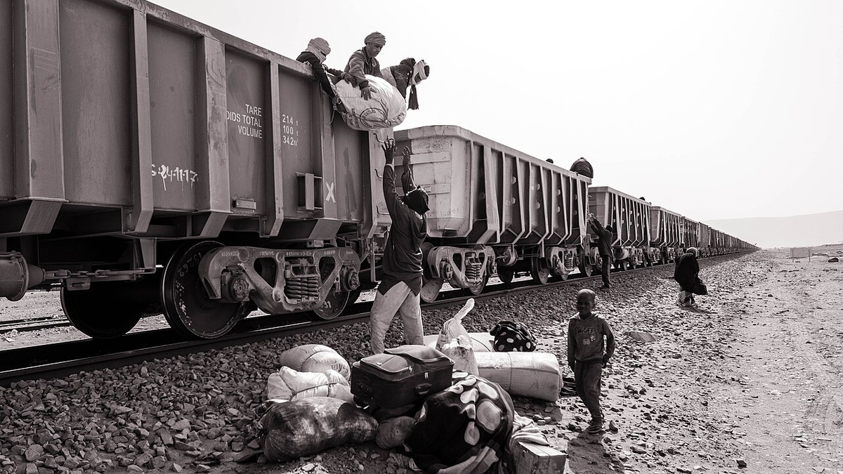
Ben Kawam, CC BY-SA 4.0, via Wikimedia Commons
Landmine belts and railways in Western Sahara and Mauritania
1. Executive Summary
The desert zone stretching from Western Sahara toward Mauritania is not an empty space. Mine, explosive-ordnance, and cluster-munition contamination remains around the Moroccan Berm in Western Sahara, while Mauritania has the internationally known SNIM iron-ore railway. These are not the same problem. The former is tied to the Western Sahara conflict and ceasefire monitoring; the latter is a mining, export, and state-infrastructure issue. 出典: Mine and explosive-ordnance context is based on UNMAS, Territory of Western Sahara and MINURSO, Mine action. Railway facts are based on SNIM, RAPPORT P3P SNIM V FINAL OCT 2024 PDF.
The mine-affected area is better understood as a linear hazard around the Berm than as one clean area total. UNMAS says much contamination is concentrated along the 1,465 km sand berm dividing the region, and that since 2008 it has released approximately 150 million square meters of hazardous land. The broader Moroccan Wall/Berm is often described as roughly 2,700 km long, so figures vary depending on the exact boundary and operational definition. 出典: UNMAS, Territory of Western Sahara and Mine Action Review, Western Sahara are the sources.
Mauritania’s SNIM railway links the mining zone around Zouerate with the ore port at Nouadhibou. SNIM’s 2024 stakeholder participation plan describes the existing railway as a 704 km single-track line from the M’Haoudatt side to Nouadhibou, with 17 passing sidings. The iron-ore train that appears in travel writing and film discussion is industrial infrastructure, not the mine belt or the Western Sahara military boundary. 出典: SNIM, RAPPORT P3P SNIM V FINAL OCT 2024 PDF.
       flowchart LR
  Conflict["Western Sahara conflict"]
  Berm["Berm contamination"]
  Mobility["Mobility risk"]
  Rail["SNIM railway"]
  Mining["Iron-ore exports"]

  Conflict --> Berm
  Berm --> Mobility
  Rail --> Mining
2. How Large Are the Mine-Affected Areas?
Western Sahara’s landmine problem is not one shaded polygon on a map. UNMAS says landmines and explosive ordnance are a legacy of the 1975-1991 conflict and that much contamination is concentrated along the 1,465 km sand berm dividing the region. Since 2008, UNMAS Western Sahara reports releasing approximately 150 million square meters of hazardous land, including 43 of 67 known minefields and 508 of 541 cluster munition strike areas. 出典: UNMAS, Territory of Western Sahara. The page gives data as of January 2026 and shows a June 2026 update date.
MINURSO’s mine-action page gives lower cumulative figures: more than 84 million square meters released, 42 of 66 known minefields released, and 505 of 540 cluster strike areas released. The difference appears to reflect update timing and scope. The important point is not a single definitive contaminated square-kilometer total. The area is managed through known hazardous areas, suspected hazardous areas, released areas, route verification, and the Berm’s length. 出典: MINURSO, Mine action compared with UNMAS.
Mauritania’s remaining contamination is also a legacy of the Western Sahara conflict. Landmine Monitor says Mauritania’s contamination stems from the 1975-1978 Western Sahara conflict and that, as of the end of 2024, Mauritania reported 22 confirmed hazardous areas for antipersonnel mines, nine confirmed hazardous areas for cluster munition remnants, 1.5 square kilometers of suspected hazardous area for cluster munition remnants, and 16.88 square kilometers of suspected hazardous area for explosive remnants of war. 出典: Landmine and Cluster Munition Monitor, Mauritania impact profile.
3. Where Are the Railways?
Mauritania’s SNIM iron-ore railway is a powerful symbol of desert mobility, but its purpose is ore transport rather than ordinary passenger mobility. SNIM’s 2024 stakeholder participation plan states that the existing railway is a 704 km single-track line linking M’Haoudatt station to the Nouadhibou ore port, with 17 passing sidings. SNIM holds the railway right-of-way from Zouerate to Nouadhibou. 出典: SNIM, RAPPORT P3P SNIM V FINAL OCT 2024 PDF.
Morocco is modernizing and expanding its rail system, but that should not be confused with the Western Sahara Berm or Mauritania’s iron-ore railway. The 2025 expansion plan reported by Reuters and France 24 focuses on major investment and a high-speed extension to Marrakech by 2030. Future concepts, tourist routes, and the existing industrial railway need to be kept separate. 出典: Reuters, Morocco launches $10 billion rail expansion plan and France 24.
4. Conflict History
Western Sahara was a Spanish colony until 1976. During decolonization, Morocco and Mauritania claimed the territory, while the Frente POLISARIO opposed both claims. After the 1975 Madrid Accords transferred Spain’s administrative responsibilities to Morocco and Mauritania, armed conflict broke out between the Polisario Front and the two states. Mauritania gave up its claim in 1979; Morocco then administered the area vacated by Mauritania. 出典: MINURSO, Background and Britannica, Western Sahara.
In 1991, Security Council Resolution 690 established MINURSO to prepare a referendum. The referendum was never held because of disputes over implementation, including voter identification. MINURSO continues to monitor military developments and reduce explosive-ordnance threats. In 2020, the Polisario Front announced withdrawal from the ceasefire and a resumption of armed struggle. Resolution 2797 in 2025 renewed MINURSO for one year and gave more weight to Morocco’s autonomy proposal as a basis for negotiations, while the Polisario Front and Algeria continued to emphasize self-determination. 出典: MINURSO, Mandate, MINURSO, Background, and Security Council Report, Western Sahara April 2026.
5. Social issues and mining-risk reading
In Western Sahara, Freedom House describes the territory as a UN-listed non-self-governing territory and says Morocco controls more than three-quarters of it. It also reports restrictions on Sahrawi activists and journalists who support self-determination. The mine issue is therefore both a humanitarian danger and part of an unresolved political-status problem. 出典: Freedom House, Western Sahara 2025, Amnesty International, Morocco and Western Sahara, and Human Rights Watch, Morocco/Western Sahara.
In Mauritania, the key social issues are the legacy of slavery, discrimination against Haratine and Afro-Mauritanians, pressure on activists, employment, and dependence on extractive industries. The SNIM train is easy to consume as an adventure-travel icon, but it is mining infrastructure tied to employment, regional development, export earnings, and state revenue. Climate pressure adds another layer: the PIK/GIZ climate profile projects a 2.0-4.5 degree Celsius temperature increase by 2080 compared with pre-industrial levels, with impacts on water, agriculture, pastoral livelihoods, drought, flooding, and desertification. 出典: Freedom House, Mauritania 2025 and PIK/GIZ, Climate Risk Profile: Mauritania.
The safety point is to separate mine belts, railways, desert tourism, and music events. Mines and explosive ordnance are security issues that require UNMAS/MINURSO and official travel-safety checks. The SNIM railway is mining infrastructure. Desert events are questions of organizer, permit status, and transport route. They may look close on a map, but their risk types and responsible actors differ. 出典: This conclusion is an inference from the UNMAS, MINURSO, Landmine Monitor, SNIM, Freedom House, and PIK/GIZ sources cited above.
References
- UNMAS, Territory of Western Sahara
- MINURSO, Mine action
- Landmine and Cluster Munition Monitor, Mauritania impact profile
- Mine Action Review, Western Sahara
- SNIM, Plan de participation des parties prenantes PDF
- MINURSO, Background
- MINURSO, Mandate
- Security Council Report, Western Sahara April 2026
- Freedom House, Western Sahara 2025
- Freedom House, Mauritania 2025
- PIK/GIZ, Climate Risk Profile: Mauritania
西サハラ・モーリタニアの地雷帯と鉄道
1. エグゼクティブサマリー
西サハラからモーリタニアにかけての砂漠地域は、空白地帯ではない。西サハラの Moroccan Berm 周辺には地雷・不発弾・クラスター弾残存物が残り、モーリタニア側には世界的に知られる SNIM の鉄鉱石鉄道が走る。地雷帯と鉄道は同じ「砂漠の危険」ではなく、前者は西サハラ紛争と停戦監視、後者は鉱業・輸出・国家インフラの問題である。 出典: 地雷・不発弾は UNMAS, Territory of Western Sahara と MINURSO, Mine action、鉄道は SNIM, RAPPORT P3P SNIM V FINAL OCT 2024 PDF に基づく。
地雷・不発弾の範囲は、単一の面積よりも Moroccan Berm とその周辺の線的な危険として理解した方がよい。UNMAS は、汚染の多くが地域を分断する 1,465km の砂の Berm 沿いに集中するとし、2008年以降に約1億5000万平方メートルの危険地を解放したと報告する。一方で、Moroccan Wall / Berm 全体は約2,700kmと説明されることもあり、どの長さ・範囲を指すかで数字が変わる。 出典: UNMAS, Territory of Western Sahara と Mine Action Review, Western Sahara に基づく。
モーリタニアの SNIM 鉄道は、Zouerate 周辺の鉱山地帯と Nouadhibou の鉱石港を結ぶ産業鉄道である。SNIM の2024年ステークホルダー参加計画は、既存鉄道を M’Haoudatt 側から Nouadhibou までの 704km 単線と説明し、17か所の待避線があるとする。旅行記や映像で目立つ鉄鉱石列車は、地雷帯や軍事境界ではなく、鉱業輸出と国家収入に結びつくインフラである。 出典: SNIM, RAPPORT P3P SNIM V FINAL OCT 2024 PDF に基づく。
       flowchart LR
  Conflict["西サハラ紛争"]
  Berm["Berm周辺汚染"]
  Mobility["移動リスク"]
  Rail["SNIM鉄道"]
  Mining["鉱業輸出"]

  Conflict --> Berm
  Berm --> Mobility
  Rail --> Mining
2. 地雷帯はどこまで広がっているのか
西サハラの地雷問題は、地図上の一つの塗りつぶし面積ではない。UNMAS は、1975-1991年の紛争の遺産として、地雷と不発弾の多くが地域を分断する 1,465km の砂の Berm 沿いに集中していると説明する。2008年以降、UNMAS Western Sahara は約1億5000万平方メートルの危険地を解放し、既知地雷原67件中43件、クラスター弾着弾区域541件中508件を解放したとする。 出典: UNMAS, Territory of Western Sahara に基づく。同ページは 2026年1月時点データと 2026年6月更新表示を示す。
MINURSO の mine action ページでは、2008年以降に 8,400万平方メートル超の危険地解放、66件中42件の既知地雷原解放、540件中505件のクラスター弾着弾区域解放が示される。UNMAS の別ページより数字が小さいのは、更新時点や集計範囲が違うためと見られる。重要なのは、総面積を一つに固定することではなく、既知区域、疑い区域、解放済み区域、Berm 長、ルート確認を分けることである。 出典: MINURSO, Mine action と UNMAS の数値を比較した。
モーリタニア国内の汚染も、西サハラ紛争の遺産である。Landmine Monitor は、モーリタニアの汚染が1975-1978年の西サハラ紛争に由来し、2024年末時点で対人地雷の confirmed hazardous area が22件、クラスター弾残存物の confirmed hazardous area が9件、さらにクラスター弾残存物の suspected hazardous area 1.5平方キロメートル、不発弾等の suspected hazardous area 16.88平方キロメートルがあると整理する。 出典: Landmine and Cluster Munition Monitor, Mauritania impact profile に基づく。
3. 鉄道はどこにあるのか
モーリタニアの SNIM 鉄鉱石鉄道は、砂漠地域の移動を象徴する存在だが、目的は旅客交通ではなく鉱石輸送である。SNIM の資料は、既存鉄道が 704km の単線で、M’Haoudatt 駅から Nouadhibou の鉱石港までを結び、17か所の待避線で列車交換を可能にしていると説明する。SNIM は Zouerate から Nouadhibou までの鉄道敷を保有するとされる。 出典: SNIM, RAPPORT P3P SNIM V FINAL OCT 2024 PDF に基づく。
モロッコ側は鉄道網の近代化・高速鉄道延伸を進めているが、現在の西サハラ Berm 周辺やモーリタニアの鉱石鉄道と同じものではない。2025年に報じられた約960億ディルハム規模の鉄道拡張計画は、2030年までの高速鉄道 Marrakech 延伸などが中心である。将来構想、観光ルート、現存の鉱石鉄道を混同すると、実際の移動可能性を誤る。 出典: Reuters, Morocco launches $10 billion rail expansion plan と France 24 に基づく。
4. 紛争史との関係
西サハラは1976年までスペイン植民地であり、脱植民地化の過程でモロッコとモーリタニアが領有を主張し、Frente POLISARIO が反対した。1975年の Madrid Accords でスペインの行政責任がモロッコとモーリタニアに移されると、POLISARIO と両国の間で武力紛争が起きた。モーリタニアは1979年に領有主張を放棄し、モロッコがその部分も管理するようになった。 出典: MINURSO, Background と Britannica, Western Sahara に基づく。
1991年、安保理決議690で MINURSO が設立され、住民投票を準備する予定だった。しかし、有権者認定などをめぐる対立で投票は実施されず、MINURSO は停戦監視、軍事動向の監視、地雷・不発弾リスク低減を続けている。2020年には POLISARIO が停戦離脱と武装闘争再開を宣言し、停戦は以前のような安定を失った。2025年の安保理決議2797は MINURSO 任務を1年延長し、モロッコの自治提案を交渉の基礎として扱う方向を強めたが、POLISARIO とアルジェリアは自己決定権を主張し続けている。 出典: MINURSO, Mandate、MINURSO, Background、Security Council Report, Western Sahara April 2026 に基づく。
5. 社会問題と鉱業リスクの読み方
西サハラでは、Freedom House が同地域を国連上の非自治地域とし、モロッコが4分の3超を支配していると整理する。モロッコ統治下では、サハラウィの自己決定を支持する活動家やジャーナリストへのハラスメント、逮捕、移動・表現の制約が指摘される。地雷問題は人道上の危険であると同時に、未解決の政治的地位問題と切り離せない。 出典: Freedom House, Western Sahara 2025、Amnesty International, Morocco and Western Sahara、Human Rights Watch, Morocco/Western Sahara に基づく。
モーリタニアでは、奴隷制の制度的遺産、Haratine や Afro-Mauritanian への差別、活動家への圧力、雇用と抽出産業依存が中心論点である。SNIM 鉄道は冒険旅行のアイコンとして消費されやすいが、実態は鉱業に依存する国家経済と労働・地域開発のインフラである。気候面では、GIZ/PIK の Climate Risk Profile が、2080年までに気温が産業化以前比で 2.0-4.5度上昇し、水資源、農牧業、干ばつ・洪水、砂漠化が生計に影響すると予測している。 出典: Freedom House, Mauritania 2025 と PIK/GIZ, Climate Risk Profile: Mauritania に基づく。
安全評価では、地雷帯、鉄道、砂漠観光、音楽イベントを同じ「砂漠の危険」として扱わないことが重要である。地雷・不発弾は UNMAS/MINURSO と各国渡航情報で確認すべき安全保障問題であり、SNIM 鉄道は鉱業インフラであり、砂漠イベントは主催者・許認可・移動経路の問題である。地図上で近く見えても、リスクの種類と責任主体は異なる。 出典: この結論は、UNMAS、MINURSO、Landmine Monitor、SNIM、Freedom House、PIK/GIZ の公表資料を統合した判断である。
参考情報
- UNMAS, Territory of Western Sahara
- MINURSO, Mine action
- Landmine and Cluster Munition Monitor, Mauritania impact profile
- Mine Action Review, Western Sahara
- SNIM, Plan de participation des parties prenantes PDF
- MINURSO, Background
- MINURSO, Mandate
- Security Council Report, Western Sahara April 2026
- Freedom House, Western Sahara 2025
- Freedom House, Mauritania 2025
- PIK/GIZ, Climate Risk Profile: Mauritania